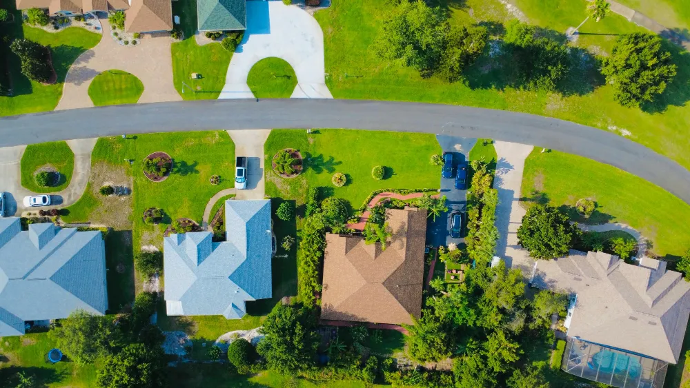
Real estate drone photography in London, Ontario costs $249 to $699. Entry packages start at $249 for MLS-ready aerial stills, photo and video bundles run $499, and adding a dedicated listing website brings a package to $699. All media is delivered within 24 hours.
What Determines the Cost of Real Estate Drone Photography?
Property size, location, and package scope set the price. Travel outside the standard service area adds to it.
Pricing for real estate drone photography varies based on a few straightforward factors. Property size and location play the biggest role — a larger lot in a rural area outside London, Ontario takes more time to capture than a downtown condo. The scope of the package matters too: aerial photography alone is priced differently than a bundle that includes drone videography, property outlining, or a dedicated real estate listing website.
Other factors that influence cost:
- Number of final edited images delivered
- Whether the package includes real estate drone videography or aerial video
- Property outlining, drawing lot boundaries onto aerial images for buyer clarity
- Turnaround time — standard 24-hour delivery versus rush options
- Travel outside the standard service area
Certification matters too. In Canada, drone pilots must hold a Transport Canada RPAS Certificate to legally fly for commercial purposes. Working with a certified drone photographer in London, Ontario protects your listing and ensures the shoot is conducted safely and in full compliance.
What Does Real Estate Drone Photography Cost in London, Ontario?
Entry packages start at $249, photo and video bundles run $499, and bundles that add a listing website run $699.
| Package | What’s included | Turnaround | Price |
|---|---|---|---|
| Photo | Aerial stills, top-down and angled, sized for every MLS portal. | Within 24 hours | $249 |
| Photo + Video | Aerial stills plus an edited aerial tour and a vertical cut for social. | Within 24 hours | $499 |
| Full Package | All the aerial media, plus a dedicated listing website with lead capture. | Within 24 hours | $699 |
Prices before HST · London, Ontario and surrounding areas. Full rate card, including videography and listing websites, on the pricing page.
Most real estate drone photography packages in the London, Ontario market start around $249. Entry-level packages typically include a set of high-resolution aerial images edited and formatted for MLS — everything you need to launch a listing without delays.
Mid-range packages that combine drone photography and real estate drone videography sit around $499. These packages are well-suited for larger residential properties, executive homes, rural listings, or any property where scale, lot size, and setting are key selling points.
Bundled packages that include aerial photography, drone videography, and a dedicated real estate listing website offer the strongest value for agents who want to present a property as completely as possible. When all three elements are delivered together, the listing becomes a cohesive presentation rather than a collection of separate assets.
"Listings with professional aerial photography sell up to 68% faster than those with standard ground-level images alone."
Source: RubyHome, citing MLS data
What's Included in a Professional Package?
Fully edited, MLS-ready aerial images delivered within 24 hours, shot by a Transport Canada certified pilot. Drone videography and property outlining are optional additions.
A well-structured real estate drone photography package should deliver media that works from the moment it arrives. That means fully edited images formatted for MLS, social media, and digital marketing — not raw files that need further processing.
Every shoot with Forest City Aerial includes:
- High-resolution aerial photography shot from multiple angles and altitudes
- Professional editing and colour correction
- MLS-ready file formats delivered within 24 hours
- Full compliance with Transport Canada certification requirements
Optional additions include drone videography — cinematic aerial video that gives buyers a sense of the property's scale and surroundings — and property outlining, which defines lot boundaries directly on aerial images so buyers understand exactly what they're looking at before they visit.
Is Real Estate Drone Photography Worth the Investment?
For most listings in the London, Ontario market, yes. The question is really about which listings benefit most.
Drone photography delivers the strongest results for:
- Properties with large or distinctive lots where ground photos miss the full picture
- Homes near water, green space, or scenic surroundings
- Rural and semi-rural listings in communities like St. Thomas, Dorchester, Thorndale, and Lucan where lot context matters to buyers
- Executive and luxury listings where buyer expectations for presentation are higher
- Any property where location is a core part of the value proposition
Listings with professional aerial photography attract more buyer attention, create stronger first impressions online, and tend to reduce the time a property sits on the market. When paired with aerial videography, that impact compounds — listings with video receive up to four times more buyer inquiries than listings with photos alone.
Adding Drone Videography to Your Package
Real estate drone videography captures what still images cannot — the flow of a property, its relationship to the surrounding neighbourhood, and the lifestyle it represents. A short cinematic aerial video gives buyers context before they book a showing, which means the buyers who reach out are already more qualified.
Aerial videography is a strong add-on for any listing where emotional engagement matters: waterfront properties, rural acreages, executive homes, or any listing where the setting is a key part of the appeal. For agents in the London, Ontario market who want to differentiate their listing presentation, video is one of the clearest ways to do it.
Dedicated Listing Websites as a Bundled Option
A real estate listing website takes the aerial photography and drone video from your shoot and organises them into a single, focused destination for that property. Rather than competing with dozens of listings on the MLS, a dedicated listing site gives buyers a distraction-free experience built entirely around one property.
Listing websites support stronger lead capture. Buyers arrive with clear intent, see the full media package — aerial photos, video, property details — and have a direct path to reach out. It is a meaningful upgrade to how a listing performs online, and it rounds out a full-service package for agents who want their listings to stand out from the first click.
Ready to Book Real Estate Drone Photography in London, Ontario?
Forest City Aerial serves London, Ontario and surrounding communities including St. Thomas, Woodstock, Tillsonburg, Aylmer, Port Stanley, Belmont, Dorchester, Thorndale, Ilderton, Lucan, Komoka, Kilworth, Mount Brydges, and Delaware. Packages start at $249 and all media is delivered within 24 hours — edited and ready for MLS.
If you're ready to elevate how your listings are presented, send the details and we'll put together a simple plan for your next property.